Planning for Spiti Valley from Delhi in august? read this
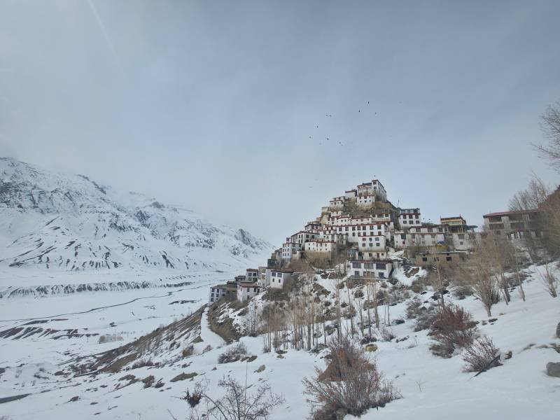
Traveling to Spiti Valley from Delhi in August presents a unique geographical paradox: while the trans-Himalayan cold desert of Spiti sits in a rain shadow and remains mostly dry, reaching it requires driving through lower and middle Himachal Pradesh during the height of the Indian monsoon.
If you pack tight schedules with zero buffer days, an August trip can quickly devolve into waiting out rockfalls or swollen mountain streams (nallahs). However, if you plan for flexible transit window, monitor real-time road conditions, and choose the right route, August rewards you with lush green Kinnaur valleys, blooming alpine wildflowers around Chandratal, and uncrowded ancient monasteries.
Key Takeaways
-
The Rain-Shadow Effect: Spiti Valley (3,800m+) receives negligible rainfall because the High Himalayas block monsoon clouds. The danger lies entirely on the approach corridors (Kinnaur's NH 5 and Mandi–Kullu's NH 21).
-
Preferred Entry Strategy: Enter via the Shimla–Kinnaur route (NH 5) for gradual altitude acclimatization. Keep the Manali–Kunzum Pass exit flexible based on same-day weather reports.
-
Buffer Days are Mandatory: Build at least 2 to 3 contingency days into your itinerary to cushion against temporary monsoon road closures.
-
Vehicle Requirement: High ground clearance (180mm+) is critical. Avoid low-slung hatchbacks or sedans on the Gramphu–Batal–Kunzum stretch.
-
Permits & Cash: Foreign nationals require an Inner Line Permit (ILP) for the Kinnaur–Spiti border zone. Carry sufficient physical cash, as network dropouts freeze UPI transactions at high altitudes.
1. The Reality of Traveling to Spiti in August: Rain Shadow vs. Approach Roads
Understanding Spiti's geography is what separates a successful expedition from a stalled trip.
The southwest monsoon dumps heavy rainfall across lower districts like Mandi, Kangra, and Shimla. Once you cross the high mountain barriers—either past Wangtu in Kinnaur or over Kunzum Pass from Lahaul—the climate shifts abruptly into a arid, high-altitude cold desert.
[Delhi] ──(Heavy Rain Corridor)──> [Kinnaur / Kullu] ──(Trans-Himalayan Shift)──> [Spiti Rain Shadow]
-
Inside Spiti (Kaza, Key, Tabo, Langza): Expect crisp daytime temperatures, bright sunshine interspersed with brief cloud cover, and dry roads.
-
On the Approach (Rampur, Powari, Malling Nallah, Batal, Gramphu): Expect active mudslides, water-fed river crossings, and periodic road clearance holds by the Border Roads Organisation (BRO).
2. Route Options from Delhi in August
The full circuit covers roughly 1,100 kilometers. How you approach this circuit in August dictates your safety and comfort.
Full Circuit: Delhi ➔ Shimla ➔ Rampur ➔ Kalpa ➔ Nako ➔ Tabo ➔ Kaza ➔ Kunzum Pass ➔ Atal Tunnel ➔ Manali ➔ Delhi
[Delhi] ──(NH 44)──> [Chandigarh] ──(NH 5)──> [Shimla / Kinnaur] ──> [Tabo / Kaza] ──(NH 505)──> [Kunzum / Atal Tunnel] ──> [Delhi]
Route A: The Shimla–Kinnaur Corridor (NH 5) — Best for Acclimatization
-
Path: Delhi ➔ Chandigarh ➔ Shimla ➔ Narkanda ➔ Rampur ➔ Kalpa ➔ Nako ➔ Tabo ➔ Kaza.
-
Why Choose This: You climb altitude gradually over 3 to 4 days, minimizing the risk of Acute Mountain Sickness (AMS).
-
August Caveat: The stretch along NH 5 near Negulsari and Malling Nallah experiences shooting stones and shooting mud during intense rain spells. Always verify road status before leaving Rampur or Reckong Peo.
Route B: The Manali–Atal Tunnel Corridor (NH 505) — Faster, Higher Risk
-
Path: Delhi ➔ Mandi ➔ Kullu ➔ Manali ➔ Atal Tunnel ➔ Gramphu ➔ Batal ➔ Kunzum Pass ➔ Kaza.
-
Why Choose This: Shorter drive time to Kaza on paper.
-
August Caveat: The 47 km stretch between Gramphu and Batal is an unpaved, river-bed track where rain-fed streams (pagal nallahs) swell by afternoon. Crossing Kunzum Pass (4,590m) on Day 2 from Delhi without acclimatization drastically raises AMS risks.
3. Spiti Valley Weather Profile in August
Temperatures vary wildly depending on altitude and time of day. While valley floors remain pleasant, high passes require heavy alpine layers.
| Region / Altitude | Daytime Temp (°C) | Nighttime Temp (°C) | Weather Conditions & Advisory |
| Lower Approach (Kinnaur / Mandi) (1,500m – 2,500m) | 18°C to 26°C | 12°C to 16°C | Humid, frequent rain spells, high landslide potential. |
| Kaza & Middle Valley (3,800m) | 12°C to 22°C | 3°C to 8°C | Mostly sunny, dry, high UV radiation. |
| High Villages (Langza, Hikkim, Komic) (4,400m+) | 8°C to 15°C | 0°C to 5°C | Cold winds, rapid drop in temperature after sunset. |
| Chandratal Campsite (4,250m) | 6°C to 12°C | -2°C to 4°C | Frigid nights; rain or light sleet possible near the pass. |
4. Key Places to Visit & August Conditions
-
Key Monastery & Kibber: Located minutes from Kaza, these high-altitude settlements sit securely in the dry zone and remain fully accessible.
-
Gue Village: Home to the 500-year-old naturally preserved mummy of monk Sangha Tenzin. The access road off NH 5 is paved but requires cautious driving past Sumdo.
-
Dhankar Monastery & Lake: Dhankar Monastery offers cliffside architecture overlooking the Spiti–Pin confluence. The 45-minute hike up to Dhankar Lake is pleasant in August, as high-altitude alpine grass turns green.
-
Pin Valley (Mud Village): A national park zone known for its distinct terraced fields and cold-desert wildlife. The Mud village road can feature small water crossings during monsoon.
-
Chandratal Lake: Campsites 3 km from the lake operate throughout August. However, the 14 km diversion track from Batal is unpaved and demands a high-clearance 4x4 or SUV.
5. Essential Packing & Survival Checklist for August
To navigate the monsoon transit and cold desert nights, pack with self-sufficiency in mind:
Vehicle & Road Recovery
-
High Ground Clearance: Minimum 180mm.
-
Recovery Essentials: Tow strap, portable tire inflator, puncture repair kit, and spare engine oil.
-
Fuel Strategy: Tank up at Reckong Peo or Manali. Kaza hosts the world's highest retail petrol pump, but monsoon delays can occasionally disrupt tanker deliveries.
Medical & Acclimatization
-
AMS Preventive Measures: Diamox (under medical supervision), preventive hydration (3–4 liters water/day), and avoiding alcohol.
-
First-Aid Kit: Anti-diarrheal medication, motion sickness pills for winding mountain passes, water purification tablets, and antiseptic dressings.
Gear & Electronics
-
Layered Clothing: Thermal base layers, fleece jacket, and a windproof/waterproof outer shell rated for sub-zero windchill.
-
Power Banks: Cold temperatures deplete lithium-ion batteries rapidly; carry at least two 20,000 mAh power banks.
-
Physical Cash: Carry enough cash for your entire stay in Spiti. ATMs in Kaza regularly run out of cash or go offline when landlines break.
Frequently Asked Questions
Is it safe to visit Spiti Valley in August?
Yes, provided you treat August as a flexible travel month rather than a rigid schedule. While Spiti Valley itself remains dry, the approach highways through Kinnaur and Lahaul experience monsoon-led disruptions. Always carry 2–3 buffer days and verify road conditions daily.
Do I need permits for Spiti Valley?
Indian citizens do not need Inner Line Permits for the standard Spiti circuit. You only need government-issued photo ID (Aadhaar or Driving License) for registration at border checkpoints like Sumdo. Foreign nationals require an Inner Line Permit (ILP) for the stretch between Kinnaur and Spiti, obtainable at Shimla, Rampur, or Reckong Peo.
Can I complete the Spiti trip in a hatchback or sedan in August?
Driving a sedan or hatchback via the Shimla–Kinnaur road up to Kaza is possible if driven carefully. However, taking a low-clearance vehicle across the Gramphu–Batal–Kunzum Pass stretch in August is strongly discouraged due to deep water crossings and broken surfaces.
References & Authoritative Sources
-
India Meteorological Department (IMD): Regional Weather & Monsoon Bulletins — https://mausam.imd.gov.in
-
Ministry of Road Transport and Highways (MoRTH): National Highway Alerts & Status — https://morth.nic.in
-
Border Roads Organisation (BRO): Highway Maintenance & High Pass Status — https://bro.gov.in
-
Himachal Pradesh Tourism Development Corporation (HPTDC): Official Travel Advisories — https://hptdc.in
-
UNESCO World Heritage Centre: Cold Desert Cultural Landscape of India — https://whc.unesco.org